Over breakfast we decided to set out east of Alice Springs to explore the East MacDonnell Ranges. The eski was packed up, suntan crème liberally plastered, sunhats and sturdy boots packed, and we were off.
The MacDonnell Ranges rise dramatically from the Central Australian desert floor, stretching east to west for 400 kilometres on either side of Alice Springs. The word "Ranges" is important because these are in indeed a collection of mountains, ridges, hills and ranges.
Immediately east of the town is the Heavitree Range, rising steeply from the dry bed of the Todd River. Across the river, immediately rising from the southern route, both rail and road, is Mount Mullin, atop of which sit the aerials for television, radio and everything else that requires such high wire structures. This space between these two geological masses is the Heavitree Gap which I have remarked on previously.
Travelling east on the Ross Highway, we arrived firstly at the Emily & Jessie Gap Nature Park. We found both these gaps to be very beautiful. The red rock walls rise above mainly dry river beds. Emily Gap is registered as a sacred site because of the rock paintings supposedly depicting caterpillars. With imagination, we were also able to see these. With imagination, one can almost see anything.
On our return to the car park at Jessie’s Gap, we were offered a slice of chocolate cake by a woman with her husband and three daughters. Pressed, we could not refuse, and soon found ourselves in conversation with them. This family of five from Yoavil in New South Wales have been on the road for a couple of years, travelling all around the country under the umbrella of the Christian Maintenance Mission. He is a carpenter and as they travel, they stay with Christian communities, repairing or building churches or houses for the congregation. Obviously their accommodation is free most of the time but the cost of travel even apart from that is no small matter. The girls are aged from nearly six to nearly ten, and were absolutely charming. We found ourselves with them for much of the day, because they, like us were exploring the Eastern MacDonnell Ranges and seemed to be interested in exactly the same attractions as us.
Thirty seven kilometres on, we pulled off to visit the Corroboree Rock Conservation Reserve. This is an Eastern Arrente sacred site and as a place of corroboree, this means a place of meeting, ceremony and celebration. Actually there is doubt as to how significant this place was as there is no water, and so why would people bother to hang out here. I have failed to mention however that the Rock is an amazing formation, shaped a little like a fan, with a couple of windows toward the top. This alone would draw a crowd.
A further thirty eight kilometres brought us to the turnoff to the Trephina Gorge Nature Park. This is noted for its sheer quartzite cliffs and River Red Gum lined water course. Two gorges dissect the range; Trephina with its wide views and sandy creek bed, and the John Hayes Rock Hole with steep, narrow walls. This second spot could be reached by four kilometres of track suitable only for 4WDs. After a very very long four kilometres, Chris admitted that it was the roughest track he had driven in the years he and I have been together, and the second roughest in his driving life. (The prize went to a track in the north of the Territory when he was working decades ago at Bamylli)
At the entrance to the park we were warned about Mulga snakes (also known as King Browns such as I met at Karamba) and dingoes but we saw none. We did however encounter Perentie monitors just short of two metres (the second largest lizard in the world) and Long Nose Dragons (also known as the Ta-ta lizard because they sometimes wave a leg in farewell as they scurry away.) High up on the edge of the canyon we came up close and personal with a friendly Spinifex Pigeon and once down on the river bed, Lincoln Ringnecked Parrots, their green feathers bright in the sunlight.
We had lunch at the John Hayes Rock Hole and later took a forty minute walk across the top of the canyon, both times encountering our missionary mates.
Again we took to the Ross Highway, travelling through great expanses of green open country, and saw Hereford cattle grazing near the road side. This land was bounded by weird and wonderful rock forms and I remarked to Chris that it reminded me of the Utah Badlands we are all familiar with from John Wayne and Brigitte Bardot western movies, except that everything was much greener and the narrow towers of the Badlands were missing. Chris thought not, but did agree that the landscape was spectacular.
At about the seventy kilometre mark, we turned off the seal and travelled a further thirty three kilometres on gravel road, crossing back and forward across river beds and then up and on to a great plain, over the cattle stop in to the Love Creek Station and on to the Arltunga Historical Reserve.
 |
| Remains of Arltunga |
 |
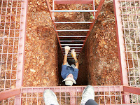
| A mine shaft for tourists |
It was late afternoon when we headed back the 110 kilometres toward Alice, arriving back at the camping ground at about six o’clock, dined and sat late into the evening watching Doc Martin and Taggart.


No comments:
Post a Comment