You know what it’s like when your cute little grandchild does something absolutely naughty and then castes that lovable smile upon you and you just melt. (This does not happen very often as a parent because you are normally too jolly tired to see past the misdemeanour.) Well such are the birds who inhabit this park, they who rise before the sun and herald its rising with superb chorus. You cannot help but rejoice despite the annoyance of being woken so early. Still, if these are the only bothersome matters of the day, one can hardly complain.
The television news
reported that wild storms had passed across the region through the night,
wrecking wind damage and a month’s downfall in a day. Geelong managed to escape
it all, so if for nothing else, we did well to stay here after all.
We spent the morning
chasing around caravan and RV accessory retail outlets, treating the rig to two
new awning pegs, two new levelling blocks and a shiny vent to cover the tree
hole. The blocks replace those that have become rather flexible and
ineffective, often having to be dug out of the soft turf by yours truly who
deals with levelling matters. Caravans are not quite as bad as boats, which are
often referred to as holes to pour money into, however they do still cost, or
at least if you wish to keep them in pristine condition.
We drove to Curio in the
north of the city, twenty kilometres north of Newcomb where most of the caravan
service industries are located, to Geelong’s BCF. This chain gives the best
value in gas refills however you do have to question the wisdom of driving for
forty kilometres to save a few dollars! I reminded Chris that we should enjoy
the journey rather than consider only the destination, and so we did, this
becoming just part of a lovely drive tour for the day.
We found a shoreline
reserve in Corio Bay, well south of the Shell Refinery, just south of the
Phosphate Co-op and north of the Bulk Wheat Loading Terminal, all of this just
east of Ford Motor Co’s factory. Slap bang in the middle of Geelong’s
industrial area; it was a delight to find this peaceful spot, with views across
Curio Bay to the Bellarine Peninsula and out beyond Point Henry to Port Phillip
Bay. From here we drove south west across the city to Fyansford, an old part of
the city one of our travel bibles had suggested worth a visit. I had conjured up
pictures of heritage cottages and shops, all quite incorrectly.
There are a
couple of old pubs there beside the Moorabool River, just upstream from its
confluence with the Barwon River. The old bridge, built in 1899, since replaced
but still used as a footbridge, is of architectural, historic and scientific
significance to Victoria. It is technologically significant as an example of
the revolutionary concrete construction technology developed in Europe in the
late nineteenth century and known as the Monier principle, this technique led
to the increased use of concrete for many new structures. Whether Fyansford is
worth a special effort probably depends whether you are interested in bridge
construction or desirous of a lunch out in one of these old pubs.
We had hoped to access
the Buckley Falls nearby, noted in minute print on our map, however after a
couple of foiled attempts, ending up in private yards, we retraced our route to
the top of the high hill above the Barwon Valley where we climbed the lookout
and were offered a better map which showed the most likely access on the
southern banks of the river.
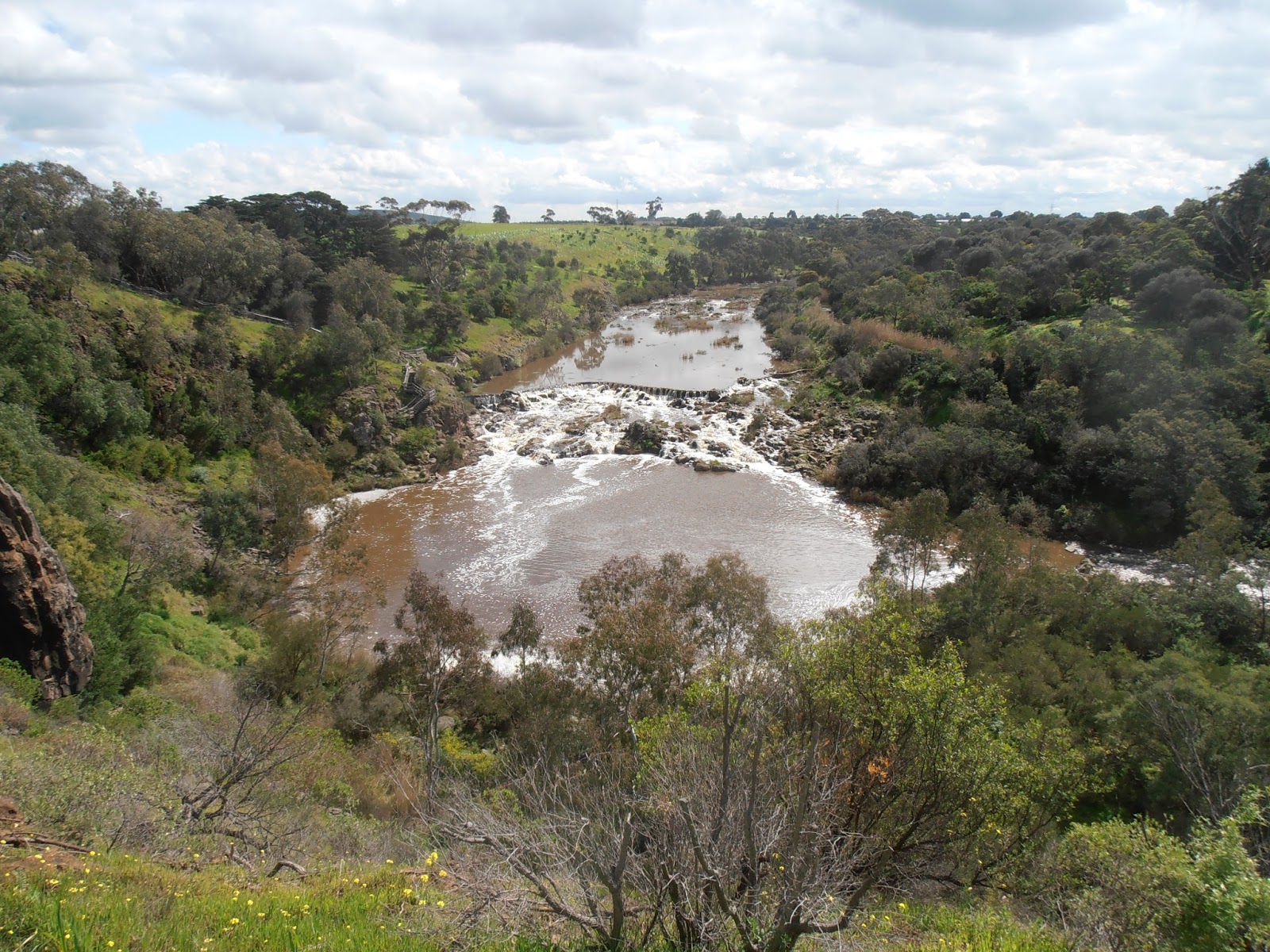 |
| Buckley Falls |
The Buckley Falls are not
promoted as a tourist attraction and the city map freely available to the
tourist, does not show many road and street names, hence we could not have
known that the falls are accessed quite simply by the road of the same name.
You may recall I
mentioned the Barwon River as we passed through Winchelsea yesterday, and it is
on this same river, which rises up in the Otway Range, and on which Lake Elizabeth is
situated. We walked up to this naturally dammed lake in early 2012, although
there it did not resemble the significant flow of water it is here in Geelong.
This river is 160 kilometres long and flows on out to the Bass Strait at Barwon
Heads, after passing through a wide wetland area, important as a Bird Area.
The Falls were in
existence long before they were manipulated and shaped further by Europeans in
1876, when a weir and water race were built above the falls, to provide power
for the Fyansford Paper Mill. They were named after the infamous William
Buckley of whom I have written before and whose name has popped up on various
geographical features around the area over the past few weeks. According to a
delightful elderly gentleman with whom we engaged in conversation above the
falls today, he who used to swim in the Devil’s Pool below our lookout, Buckley
was actually found here at the falls. Nothing in the stories I have read about
this escaped convict, who spent thirty two years with Aborigines from 1803, confirms
this, but it is a good story.
 |
| The old Fyansford Paper Mill or whatever |
We did find notes about
past flooding of the river here; in 1995 the river level rose to 5.23 metres.
This was a one in forty year flood, the previous major flood having occurred in
1952 when the water rose to 5.47 metres, then classed as a one in eighty year
flood. The interpretative panels were erected before more recent floods, and I
found a report in the local paper dated 14 January 2011 warning that the river
was expected to rise to 7.5 metres that morning. Whether it did or not I am not
sure, however the moral of the story is that in Australia, do not build close
to a river, even if they flood only once in fifty years.
Back near the car park,
we found a van load of Christian College kids all clad in wetsuits and life
jackets, a long string of canoes, and an instructor giving “how-to” advice
before they set out onto the river. We did not hang about to watch the launch,
but instead drove back up to the city to look for my
great-great-great-grandfather’s 1856 residence in O’Farrell Place, North
Geelong.
This turned out to be
quite a surprise, because O’Farrell Place is a tiny lane off Gheringhap Street,
in central Geelong, not the north. Today the old buildings lie cheek by jowl
with old buildings that may or may not have existed back in that day, and all are
used for commercial purposes. This whole affair raised yet another question:
Charles Lake’s daughter, who went on to produce my ancestors and I, was
apparently born in Gheringhap, which today barely exists along the road to
Ballarat. When we passed this tiny spot on the map early last year, I wondered
what the Lakes were up to there, however after today’s discovery I do wonder if
Emma was not born on the corner of O’Farrell and Gheringhap Streets, right here
in Geelong, and that the information I have is incorrect. Thus are the
challenges of genealogy and I will have to apply myself to this new mystery. A
birth certificate should sort it all out.
As we pulled into camp,
we wondered at the ominous clouds above, however even as I write this, some
hours later, the sun is still shining and we are inclined to disregard the
weather forecast for the morrow.
No comments:
Post a Comment